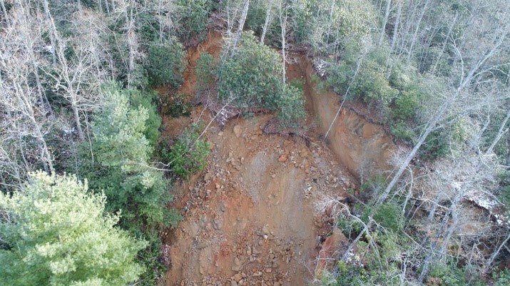
S&ME was hired to provide emergency aerial photography and to a three-dimensional model for a rockslide. The rockslide was located on Highway 28, in the area known as the “Tail of the Dragon,” near Fontana Village, North Carolina.
Challenges: Due to the urgency, the S&ME team reported to the site within 24 hours of notification. Site conditions encountered were mountainous and heavily forested terrain. An active rockslide containing head scarps of up to 15 feet in height, numerous internal scarps, and large blocks of actively sliding rocks made collecting data while on the slope hazardous and time consuming to survey. S&ME recognized the importance of a quick turnaround of information due to the road closure of HWY 28.
Deliverables: The team was able to safely and efficiently capture over 150 photographs and 4K video of the site. The images were taken through a free flight with manual overlap. The images were captured between 30 feet to 50 feet above ground elevation. From the images, S&ME created a surface model from the point cloud containing a density of ¼ to 1 inch per point. Our team provided NCDOT with deliverables within one week of the site visit.
By using the flight data, S&ME produced a surface model, aerial imaging, and videography which allowed for the creation of the following:
- A design file model in micro station,
- Production of accurate existing ground lines and cut slope cross-sections using the model, tied to stations, offsets and elevations,
- Model allows for importation into CRISP Analysis of proposed cut slope designs,
- Estimate the volume of material to be removed,
- Estimate the square footage of the Draped Mesh,
- Provide contractors with a current aerial map of the disturb limits,
- Provide the NCDOT Headquarters with video documentation of the existing condition of the rockslide.
Advantages: Aerial imaging can provide high-resolution scalable images of high walls, existing rock cuts, and landslide materials including boulders and surrounding ground surfaces. Utilizing survey points on the roadway eliminates the need for surveyors or others to traverse these very hazardous areas. The imaging can be used to visually assess the designated area in a safe manner and document the conditions of the geology. Images can be produced in as little as 1 day. CAD files can be produced in 2 days for landslides (rock cut cross-sections can be produced in 4 to 5 days including the overhangs or undercuts). The S&ME, Inc. approach allows for a safer and more efficient turnaround for providing clients with documentation. The approach also offers a solution that reduces exposure of personnel to the rockfall hazards and potential dangers of working near traffic.