
December 23, 2025
Insights from S&ME Technical Principal, Aaron Golberg, PE, D.GE
South Carolina’s Lowcountry is known for its marshes, historic sites, and coastal communities, but it also sits within a geologically active region. Seismic risk in this area is real, and it plays an important role in how engineers approach geotechnical design and infrastructure planning.
Understanding Seismic Activity
While South Carolina isn’t associated with seismic events like its West Coast counterparts, it’s not immune to tremors.
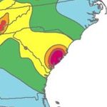
The earthquake risk for the southeastern United States, including South Carolina, is dominated by the Charleston Seismic Zone. Named after the city where a significant earthquake struck in 1886, this zone is the source of the greatest earthquake risk for most of South Carolina, North Carolina, and Georgia.
Lowcountry Geotechnical Considerations
Understanding the geological makeup of the Lowcountry is crucial for infrastructure development and land use planning. The region’s geotechnical considerations are influenced by its unique blend of coastal plains, marshes, and river deltas.
Learn How S&ME Designs for Earthquakes

- Soil Composition: The Lowcountry’s soil composition varies, ranging from sandy soils along the coast to clay-rich soils further inland. These diverse soil types react differently to seismic activity, impacting building stability and foundation design.
- Water Table Dynamics: The proximity to the coast and intricate network of rivers and estuaries means that water table dynamics play a significant role in geotechnical engineering. Seismic events can potentially trigger liquefaction in saturated soils, leading to ground instability and potential structural damage.
- Infrastructure Vulnerability: The region’s historical architecture and urban development pose unique challenges in retrofitting existing structures to withstand seismic events. Balancing preservation efforts with modern safety standards requires innovative engineering solutions tailored to the Lowcountry’s specific needs.
- Coastal Erosion: Beyond seismic considerations, the Lowcountry grapples with coastal erosion, exacerbated by factors such as sea level rise and storm surges. Geotechnical strategies for shoreline protection and land conservation intersect with seismic resilience efforts to safeguard communities and ecosystems.
S&ME Earthquake Engineering Projects in Lowcountry
I-95 Widening
As part of the KCI team, S&ME performed geotechnical explorations along the entire project corridor to characterize the subsurface for the bridges and roadways. The field exploration consisted of:
- Soil test borings (STB)
- Cone penetration test (CPT) soundings
- Seismic cone penetration test (SCPT) soundings
- Dilatometer test (DMT) soundings
- Bulk soil (BS) sample collection
- Multi-Channel Analysis of Surface Waves (MASW) testing.
Over-land, barge-mounted, and amphibious drilling platforms were utilized to complete the exploration. Multiple SCDOT certified Disadvantage Business Enterprises (DBE) were utilized in our field exploration program.
S&ME also performed a site-specific response analysis to evaluate the seismic hazard and the risk of soil liquefaction and impact on the proposed bridges was determined. Liquefaction mitigation design was accomplished using methods adopted from Caltrans (California DOT) and ground improvement where needed.
Complete I-95 Widening Project Description
Dockside Condominium Seismic Evaluation
At the Dockside Condominium complex in Charleston, SC seismic performance directly affects a mix of building types and occupied spaces. The site includes an approximately 20‑story residential tower, surrounded by two‑story townhomes built atop a plaza level with asphalt parking below. Understanding how this layered development would respond during an earthquake was a key part of the evaluation.
The work began with a review of existing geotechnical data, followed by the collection of new subsurface information. Cone penetration test (CPT) soundings and downhole shear wave velocity measurements were performed to better define site conditions and support the structural team’s seismic assessment.
The evaluation followed ASCE 41‑17 and included a site‑specific seismic response analysis (SSRA), along with an assessment of applicable seismic geologic hazards outlined in Section 8.2.2 of the standard. The SSRA considered both BSE‑1E and BSE‑2E hazard levels, representing earthquakes with 20% and 5% probabilities of exceedance in 50 years.
These analyses provided a clearer picture of how the site’s geology and structural systems would behave under varying levels of seismic demand.